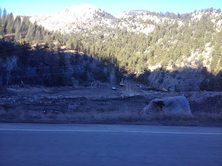
All around Colorado are signs of the September flood. It wasn't an isolated area, the flood hit almost 5 mountain creeks and their courses. It spread from Estes in the mountains to front range communities of Fort Collins, Loveland, Longmont and Boulder. It spread east to Greeley and all the towns along the North Platte river. On our 4 hour drive to Estes that first time five days after the flood, it was under clear beautiful blue skies. If it wasn't for the massive road damage and debris all over everywhere, the flood would have seemed like it never happened.
About 5 miles south of Estes is where M saw the biggest signs of the flood. Behind one resort, was a massive flood plain.

Coming around the corner, M realized the floodplain was caused by the massive mudslide which wiped out a good stretch of Twin Sisters mountain.
There were other rockslides and mudslides along the roads that pushed debris over the road and caused damage. It wasn't just rivers that caused damage, it was also the massive rock slides and tree debris pushed along by tons of water pressure.

Right by one of the most historic sites outside of Estes Park, was a log jam. The only explanation M had was the forestry work and slash piles that had been building up in Rocky Mountain Park due to beetle kill were washed down the slopes by the water. This caused the water to build up and overflow across the road.
M and D highly debated about whether C and I would join M up in Estes that first week. School had obviously been cancelled the day of the flood and the day after. It was still shut down Monday because of sewer line damage. But Monday afternoon, both the elementary school and the preschool were scheduled to open their doors on Tuesday. Since a lot of my friends and classmates were still stranded, 19 teachers who reside in the valley and port-a-potties as the other restrooms, school was not mandatory but a safe area for kids to gather while parents worked at cleaning.
We made it to school just after 10 that first morning. Since buses weren't running, M picked me up from school and we went to look at the road below the bus barn--Fish Creek. This was really the only road damaged in Estes, but because the sewer lines ran underneath the road, all the neighborhoods on either side was declared a "no-flush" zone and would remain so for the next 7 weeks as repairs happened.
Fish Creek was the shortcut we used from Hwy 34 over to school. The intersection of Fish Creek and Brodie avenue is about 1/4 mile below the school and where we would turn. Now a 20 foot ditch is there!

In the days following, helicopters were a common site. The day we drove up to Estes 1200+ people were air evacuated from remote mountain areas that were cut off because all the major roads were damaged or destroyed.
Other scenes from around Estes included a stable that is now in a river plain rather than on the banks...
bridges damages as the water washed away foundations.

In one river bank M found a gate with locks still attached, no where near the road it once helped block.

and signage in window alerting passbyers of the damage to businesses. This store was where M worked a second job for a brief 10 months right before M&D were married. The yellow sign is stating that the business is only open for clean-up.

Although most of the water had receded in downtown by the time we got to town, there were still areas of standing water and the river was still running pretty high.
Evidence of the huge amounts of mud that was carried by the water. 

As more and more areas opened to the public in the days and weeks following the flood, there were unreal images of damage. Along one major highway is a junk yard were damaged vehicles are being taken. At first glance, this camper looks just fine. But on second glance, you can see the high water mark from bumper to hitch, ending right below the bedroom window, which is at least 8-10 feet off the ground.

Just one of many cars still sitting along the riverbank. If it wasn't for the wheels you wouldn't even know it used to be a SUV/jeep of some sort.

There are houses along the river that have mud and debris pushed into them....

and some houses that are barely holding on, as the bank was washed away under them.

Whole bridges were washed away and all that remain is the cement foundation.

Around the clock work is being done to get roads repaired. Lake Estes was drained and is being dredged to use for road base. Since at one point the only road not damaged into Estes was Trail Ridge that climbs to more than 12,000 feet as it travels through Rocky Mountain Park, it was closed in order for the caravans of earth-moving equipment, rock crushers and other heavy equipment being moved into Estes in the days following the flood.
Big Elk Meadows road is being rebuilt and culverts replaced.

Condos and resorts in Estes are working hard to claim back what the river took from them.
A few weeks after the flood, the leaves were changing, the mountains had snow on them and it was just a "normal" day in downtown Estes.


No comments:
Post a Comment